NOTICE OF VACANCY - SEER GREEN
Local Government Act 1972- Sections 87 and 89
A casual vacancy has arisen in the Office of a Parish Councillor for Seer Green Parish Council. If you are interested in the role please contact the Parish Clerk.
Seer Green Parish Council Response to Informal Sites Engagement Survey - Local Plan - 13th March 2026
Seer Green Parish Council has already made representations to Buckinghamshire Council’s Planning Department as a contribution to the initial Draft Local Plan consultation last October. Please see the document below.
In response to the Informal Sites Engagement Survey, Seer Green Parish Council comments as follows:
The following three plots are contiguous and comments apply to all three sites. These will support the designation of ‘unsuitable’ for development:
OPUS 3691 – Land North of Highland Road, Seer Green, HP9 2BG
This site has been designated as ‘Unsuitable’ due to its location within the Green Belt.
Local knowledge: This site has no access to any road. Access would have to be created via the small cul-de-sac at the end of Highlands Road, which was not designed to take large volumes of traffic, being a quiet residential road.
The site is also prone to flooding after heavy rainfall, thanks in part to the heavy clay soil which drains poorly, causing damage to gardens backing on to the site and run-off water flooding down Bottom Lane to the junction with Longbottom Lane. This has resulted in numerous car write-offs in the past as well as damage to the roads.
OPUS 3412 – Land to the North West of Chalfont Road, Seer Green, HP9 2XP
This site has been designated as ‘Unsuitable’ due to its location within the Green Belt.
OPUS 3335 – Land West of Chalfont Road, Seer Green, HP9 2XP
This site has been designated as ‘Unsuitable’ due to its location within the Green Belt. Additionally, the site also appears in the Local Nature Recovery Strategy (LNRS) published by Buckinghamshire Council last year as an 'area that could become important to biodiversity'. As such, the case to protect is even further enhanced and endorsed by the Council themselves as part of their strategy.
Local knowledge: These two sites (OPUS 3412 and OPUS 3335), in common with OPUS 3691, flood regularly after heavy rainfall, inundating the gardens of Howard Crescent and Highlands Road. The compaction and heavy clay nature of soil and little or no drainage are all contributing factors.
The development of these two sites would inevitably result in the loss of the ancient hedgerows that border them on the Chalfont Road, as this would be the only point of access for any new development. The harm to the environment would be incalculable and no amount of biodiversity mitigation would compensate for the loss of the hedgerows and the habitat for the abundance of wildlife they contain.
General Planning comments for all three sites:
• The sites are greenfield and do not meet the criteria to be considered Grey Belt
• Potential harm to the openness of the Green Belt
• Encroachment into the countryside
• Expansion of the village settlement by extending the north-western boundary, thereby harming the rural character and setting of Seer Green in addition to moving the built form even closer to Chalfont St Giles
• Unsustainable development due to lack of road access
• No non-car option for accessing key services such as shops, pharmacies, schools and GP surgeries
• Pressure placed on schools, public transport system (already scarce) and roads by the addition of a large number of cars
• Unacceptable harm to ecology caused by the loss of hedgerows and wildlife habitats.
OPUS 1096 – Oldefields Equestrian Centre, Chalfont Road, Seer Green HP9 2PD
This brownfield site has been designated as ‘Unsuitable’ for development due to its location within the Green Belt, inappropriate alteration to the Settlement pattern and intrusion into the open countryside.
Local knowledge: This site forms part of an open vista across the countryside to the north western side of the settlement of Seer Green. Although a brownfield site, its current use is as a livery stables, blending in with the rural nature of its setting. Development of this site would inevitably close off the openness of the Green Belt on this side of the Chalfont Road, which has had various failed applications for development in the past (CH/1191/84, CH/2018/40029/IQL and PL/2/0999/OA as examples). Additionally, given the shape of the site, this could constitute ribbon development, to the detriment of the Green Belt. In past years, we believe that this site, together with the preceding three, have variously been put forward and rejected at Stage 1 of the HELAA under the emerging Chiltern & South Bucks Local Plan.
Planning considerations:
• Unacceptable harm to the landscape and an unacceptable intrusion into open countryside.
• Unacceptable harm to ecology due to the inevitable removal of hedgerows to create access to the site
• Unsustainable for development because the site would not offer non-car options to residents in order to access key amenities such as schools, GP surgeries, shops and pharmacies.
• Unsafe walking due to no pavement on that side of the busy Chalfont Road
OPUS 3204 – 112 Chalfont Road, Seer Green, HP9 2QP
This greenfield site to the north east of Chalfont Road has been designated ‘Provisional Grey Belt’ and has been put forward as a site that might be suitable for residential, solar farm or other development.
Local knowledge: This site is south of the Perkin Elmer site (already being developed to provide 31 dwellings = see below). The land has been in agricultural use (vineyard and associated barn with separate access to Chalfont Road. This site, if developed as a residential site would affect the openness of the Green Belt, the character and settlement pattern of Seer Green, adding to ribbon development along Chalfont Road.
Planning comments:
• Unsustainable development would not offer residents non-car options to allow access to key services such as GP surgeries, pharmacies, shops and schools
• Harm to the landscape and would be an unacceptable intrusion into open countryside
• The site is in the Green Belt and does not meet the criteria to be considered Grey Belt.
OPUS 19 – Perkin Elmer, Chalfont Road, Seer Green, HP9 2FX
This brownfield site has been designated as ‘provisional grey belt’, with further assessment required. However, planning consent has been given (PL/21/2142/OA) for 31 dwellings on the site and site clearance has already commenced. This development to the north of our village will increase the size of the village by some 3%.
OPUS 1279 – Bowl Barrow Way, Beaconsfield, HP9 2UP
This greenfield site (partially within our parish boundary) has been designated as ‘Provisional Grey Belt’
Local knowledge: If developed, this site would unite Beaconsfield with Seer Green, thus subsuming our village into the greater settlement. It is of great concern to Seer Green Parish Council that this should not happen. The Green Belt site is a vital green buffer between our village and the town of Beaconsfield and its development would not only harm our settlement, it would also cause an unacceptable loss of woodland and unacceptable loss of community facility.
Planning comments:
• Unacceptable harm to the landscape and would be an unacceptable intrusion into open countryside
• Development would cause unacceptable harm to ecology with the loss of woodland
• Does not meet the criteria for designation as ‘Grey Belt’ as the land has not been previously developed and strongly meets Green Belt purposes as defined by Central Government.
• Unsustainable development as it would not offer residents non-car options and safe routes to access key services such as GP surgeries, shops, pharmacies and schools.
• Access to key services without a car would require walking on insufficiently lit roads and/or roads without pavements. This would deter the elderly, parents with children and anyone walking in darkness.
OPUS 3653 – Land to the South of Longbottom Lane and East of Dean Wood Road, HP9 2UT
This Greenfield site lies just outside the Parish of Seer Green (it sits within Chalfont St Giles parish) and has been designated ‘Provisional Grey Belt’ with unconfirmed suitability (further assessment required).
If this site is taken in conjunction with OPUS 1279 (see above) it will be seen that the two sites would completely enclose the historical Beaconsfield Golf Club, destroying natural woodland and creating a vast addition to the town of Beaconsfield. Seer Green would simply become a ‘suburb’ of Beaconsfield and lose its rural identity.
Seer Green Parish Council response to the proposed Local Plan for Buckinghamshire (reg 18).
Buckinghamshire Council is preparing a new Local Plan that will identify where and how future development should take place up to 2045. A public consultation on the draft Local Plan rand from runs from 17 September to 29 October 2025.
The draft Local Plan for Buckinghamshire has been prepared in two parts:
Part A: The Local Plan vision and objectives, the spatial strategies for housing and employment, including ways to meet travelling communities’ accommodation needs.
Part B: Development Management Policies.
Given the scope of the consultation and its relevance to our village, the Parish Council is opting to comment rather than complete the consultation document. While we are aware that the Local Plan is not looking at specific proposed development sites (as stated on the latest HELAA map) at this point, the existence of three such sites (one already approved for development) colours the response to the Local Plan Consultation.
Introduction
As a small village of just over 950 households, we are concerned that the ever-decreasing acreage that protects Seer Green from being subsumed into the settlements of Beaconsfield, Chalfont St Giles and Jordans will be further eroded and the Green Belt that contributes so greatly to the quality of life, biodiversity and beauty of our part of Buckinghamshire will eventually be lost.
At today’s date, the village of Seer Green meets Local Objectives (as proposed) 1,2,3 and 4 in full. We are privileged to live in a settlement that supports and enhances the lives of our residents in their current numbers, providing recreational and outdoor facilities that are partially sufficient for our existing households.
The village benefits from two churches, two nurseries, one pre-school, one primary school, two public houses, one convenience store, one butcher, one beauty parlour, one dog-grooming parlour, one car showroom and one motor services garage. All other services and leisure requirements necessitate travel to Beaconsfield (nearest town), Chalfont St Giles, Chalfont St Peter, Gerrards Cross and Amersham, mainly by means of private cars.
With the creation of ‘Grey Belt’ land (defined as ‘land that has previously been developed or does not strongly meet Green Belt purposes as defined by Central Government), we are seeing developers rushing to obtain planning approval for completely inappropriate and unsustainable developments and old, rejected planning applications dusted off and re-presented in the hope that the current more relaxed rules will allow them to go forward. The current HELAA site map shows three sites proposed for possible allocation, all to the north of Seer Green. One of these (designated the ‘Perkin Elmer’ site and the only brownfield site in the village) has already obtained planning permission- on appeal - for a development of 31 dwellings, enlarging our settlement by over 3%, leaving the other two for consideration
Over the years, these two sites and surrounding land have applied for, and had rejected, various planning applications (eg: CH/1191/84, CH/2018/40029/IQL, the last being PL/20/0999/OA) and we believe the land was also proposed and rejected at Stage 1 of the HELAA under the emerging Chiltern & South Bucks Local Plan.
These two sites are Green Belt land, bounded in part by hedgerows that historically date back to the 16th century, provide an open buffer space between the last houses of our settlement on the western side of Chalfont Road and the more rural farmhouses to the north of our Parish and Hodgemoor Woods, a nationally-important SSSI. This land contrasts sharply with the ribbon development on the opposite side of Chalfont Road which extends to the boundary with the new Perkin Elmer development site.
The two sites potentially under consideration fail to meet the NPPF 2024 criteria on a number of fronts – as would be the case with any sites within our parish boundaries. These points are:
Presumption in favour of sustainable development
The proposed sites fail to promote sustainable development, putting adverse pressure on local infrastructure, most notably: the capacity of local primary schools; remoteness from secondary schooling, healthcare, retail and sports facilities and related paucity of existing public transport services, making Seer Green residents predominantly reliant on private car use in order to access basic facilities. The sites therefore fail to align growth and infrastructure and would be detrimental to the environment.
Draft Plan Consultation Part B Transport
Although the Buckinghamshire Settlement Review places Seer Green in Tier 4 with ‘Good’ transport links, the reality of these sites, and the village more generally, is that while the sites are proximal to the main road (Chalfont Road) and therefore the bus route through the village, they are distal to the railway station, and with the village lacking crucial elements of community infrastructure (education, health, retail, employment), large scale development here or elsewhere in the village will lead to significantly increased vehicle movement and pressure on the already-stressed local road network. In addition, a major development would carry implications for transport infrastructure to widen transport choice, but the local road network in and around Seer Green has very limited capacity to support this.
Draft Plan Consultation Part B Protection of Green Belt
Seer Green has been placed in Tier 4 Large Village of the Settlement Hierarchy. This implies that Approach No. 6 is relevant and that Seer Green may be suitable for limited infilling, even though the village is situated in the Green Belt. However, the nature of the ‘clustered’ development of the village over the centuries has been one of ‘outside-in’, with the boundary properties to a large extent enclosing later infill development. There is therefore no scope for further ‘infill’ development. It follows that any further development would inevitably take place on Green Belt sites which protect the nature and character of the village as well as providing natural habitats for our species-rich wildlife. Our Green Belt protection also provides a buffer between our settlement and the historically-significant and nationally important SSSI, Hodgemoor Woods, less than 1km from the proposed sites. Seer Green’s proximity to Burnham Beeches SAC has also been a contributory factor to the refusal of the latest planning application for the sites in question.
Draft Plan Consultation Part B Infrastructure
The Baseline Infrastructure Study has highlighted deficiencies or capacity limitations in Seer Green’s infrastructure, particularly in the areas of public bus services, sewage system, education, community facilities, healthcare, employment opportunities and a heavy reliance on facilities provided by nearby towns. Further development within our Parish boundaries would inevitably result in further pressure on our already-poor public transport services and an increase in the use of private vehicles to access services and facilities, thus contributing to the county’s carbon footprint, rather than mitigating or reducing it.
On a more practical note, the land in question floods regularly whenever there is a high level of rainfall, flowing into the back gardens of residents of Howard Crescent as well as rendering the main road through the village (Chalfont Road) impassable at that point. This necessitates constant monitoring of drainage ditches and expensive remedial work by Buckinghamshire Council in an effort to prevent further flooding downhill, which effectively cuts our village off completely from the outside world. Any further development at this location will only exacerbate an already-intractable problem.
Conclusion
Seer Green is not a suitable village for further development, which would be to the detriment of the Green Belt and biodiversity, place pressure on our transport system and our infrastructure and would inevitably necessitate the upgrading of our sewage system and flood mitigation measures.
Seer Green Parish Council hopes that our comments will be taken into account when the Draft Plan is formulated for submission.
SGPC Village Facilities Survey 2024
The 2024 survey built on previous surveys & was intended to elicit an understanding of how certain village assets are used & valued, & how they could be enhanced.
It was carried out in September/October 2024
Respondents could use a paper copy in the SGPC biannual newsletter or an online response form, the URL for which was given in the newsletter and also a link provided in the village WhatsApp chat group.
The survey was a mix of 9 closed & open questions relating to; Green Meadow, the Recreation Ground, Biodiversity & General suggestions.
The link to the following slides aim to provide an analysis of the survey results.
In order to better identify trends & themes in the responses to open questions, similar responses have been grouped together.
Please see the attached link for the detailed results of the recent SGPC Village Facilities Survey 2024Flooding Update
19th November 2024
The drain and ditch at the junction of Bayne Hill and Long Bottom were cleared and jetted through to stop the water flooding this corner of the carriageway.
5th November 2024
The drains and soakaway in Rawlings Lane have been cleared of silt. The drains in Long Bottom Lane have started to be cleared and the ditch at the junction of Long Bottom Lane with Jordans Lane has been cleared again.
24th October 2024
Bucks Council Highways have scheduled to clear the blocked drains on Rawlings Lane on 5th and 6th November and the Bottom Lane drains (which have re-blocked since July) on 6th and 7th November 2024. The roads will not be closed at the same time.19th July 2024
Bucks Highways Cyclic Gully clearance programme cleared the drains and gullies in Bottom Lane.
12th July 2024
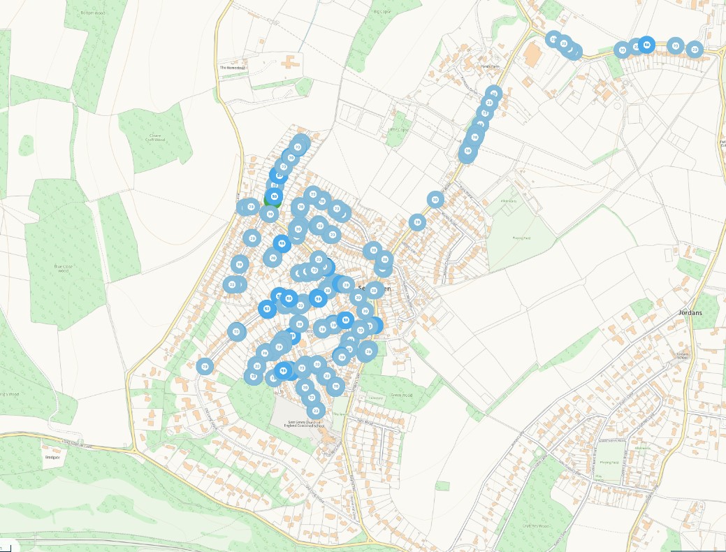
Bucks Highways Cyclic Gully clearance programme started in Seer Green during June where they attempt to attend to every drain/gully where possible (not just sites reported). The map shows a map of the areas that the cyclic programme has covered so far with each blue dot on the map representing a gully cleared.
31st May 2024
On 8th and 9th May the ditch was cleared on Bottom Lane close to the junction with Long Bottom Lane and on 22nd May it was recorded that the ditches were now filling with water from the drain. The drains and gullies on Bottom Lane and Long Bottom Lane should be cleared over the summer. On 30th May the ditch on the corner of Long Bottom Lane and Potkiln Lane was significantly cleared. This should help the flooding on this corner.
24th February 2024
Latest information that we have received from Bucks Council:-
Longbottom Lane was scheduled to be repaired 3 weeks ago. The road was due to be closed for 3 days to allow for extensive work - not just filling potholes, but resurfacing the badly damaged sections. However, the wet conditions meant any repair work attempted would have failed within days, so it was postponed.
The work will be booked in as soon as it is forecast to have a few days of dry weather, which will allow the Council to make proper, lasting repairs. This was confirmed with the Cabinet Member for Transport yesterday.
On Wednesday (20th February), Bucks Council voted to add £5 million to the road repair budget for this financial year. At the Full Council meeting our County Councillor Carl Jackson specifically requested Longbottom Lane and Bottom Lane should be prioritised for work using the extra money.
21st February 2024
In the last 4 months Seer Green entrances to the village have been flooded on Monday 13th November 2023, 9th December 2023, 5th January 2024 and 18th January 2024. Work has been carried out by Bucks Council to alleviate some of the issues. Below is an update of the current status.
Newbarn Lane: Drain clearance was carried out by Bucks Council on 12th December 2023 but both sides of the carriageway still flood. The Capital Drains Team informed the Parish Council that “we are aware that the soakaway on the corner of Newbarn Lane may need a borehole to remove this area of flooding and we are hoping that this could be installed this coming financial year.” We understand that the work is in the Capital Drains Team 5 year plan. The Parish Council have requested that this work to be scheduled ASAP.
The Bucks Council Highways Local Area Technician and the Parish Council have been discussing the fact that the flooding on Newbarn Lane is partially being caused by a significant amount of water coming from Rawlings Lane, further investigation is needed by the Local Area Technician, which is already underway. The recutting of small sections at the side of the ditch on Rawlings Lane needs to be carried out to make it more effective and so that it takes more water from the road surface. The Local Area Technician has ordered this work.
Chalfont Road was flooded across both carriageways on Sunday 18th February 2024 but it was passable on one side as the Bucks Council Super Sucker had cleared out the drains, gullies and borehole on 26th January 2024. Bucks Council completed a significant expansion of the drainage system on Chalfont Road in 2022 to take more water off the road. There is an illegal drainage of water from private land onto the Highway being currently being investigated and dealt with by Bucks Council.
Bottom Lane has no drains/gullies for about a mile from Rawlings Lane at Hodgemoor Wood down to the bend towards the junction with Long Bottom Lane. At this point there are approximately 9 drainage points outside 3 properties which were all cleared by the Super Sucker on 25th January 2024. However, the water from these drains just goes into the ditch at the side of the road which is full. Further work is required to the ditch to allow it to take more water. We understand that our Bucks Highways Local Area Technician has raised orders for this ditch clearance and we are waiting for details for when this work will be carried out.
The water at the end of Bottom Lane is pooling badly across both carriageways of Long Bottom Lane during heavy rain. Part of the issue is due to the drains being blocked on Long Bottom Lane. The water has eroded the surface of Long Bottom Lane which now needs resurfacing. We understand that Bucks Council were due to do resurfacing work two weeks ago but the work was cancelled due to bad weather. Dates for this comprehensive repair have been requested from Bucks Council.
A section of Bottom Lane is in a terrible condition due to the heavy vehicles used for two large developments. We are concerned that the site run off water is affecting the road and adding to the existing problem caused by lack of drainage. Bucks Council have struggled to repair the road due to the wet weather and high number of vehicles on this road which has a sign saying Unsuitable for Heavy Vehicles. Bucks Council have told us that they plan to carry out a proper resurfacing when the developments are complete. The situation is being monitored by the Local Area Technician.
Long Bottom Lane:- Highways informed the Parish Clerk on 9th February 2024 that the drains on Long Bottom Lane are due to be cleared before the end of this financial year.
There is a blocked drain on Potkiln lane which we had previously reported on Fix My Street. The drain pipes from Long Bottom Lane to the ditch and field beyond have been cleared in the last two weeks. The Bucks Council Waste Team has had the Road Sweeper down as requested to clear the surface mud. The ditch urgently needs clearing and this work has been ordered by our Local Area Technician.
The drain at the bottom of Bayne Hill reported back in March is still solidly blocked hampering the water getting to the drainage ditch which was cleared by Bucks Council last year. An order has been raised for this work.
We are concerned that a development between Bayne Hill and Bottom Lane on Long Bottom Lane may have blocked the drains and there is a ‘mud on the road’ sign where this has happened. This issue is being investigated by the Local Area Technician and the drains, gullies and ditch need clearing.
The Parish Council has written to Martin Tett, Leader of Buckinghamshire Council raising the concerns and asking for him to work with the Parish Council to ensure that the Capital Drains Team, engineer a long term and effective solution for the Bottom Lane/Long Bottom Lane area of the village.
The Parish Council continues to log highways issues on Fix My Street on a weekly basis and encourages residents of the village to do the same. Progress meetings are held with Buckinghamshire Council. Our Buckinghamshire Councillor, Carl Jackson often attends the Parish Council meetings to discuss the issues and escalate them within Bucks Council.
If you wish to discuss the above or any other concerns with the Parish Council please email the Parish Clerk on clerk@seergreenparishcouncil.gov.uk or please come to the Parish Council meeting on the first Tuesday of every month (except for August) at the Baptist Church in Wood Pond Close at 7.30pm.